
(NEW YORK) — Dozens of fires are burning throughout the West as parts of the country remain under advisories for high temperatures.
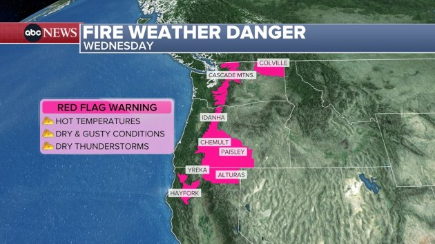
Red flag warnings are in place for Northern California and parts of Oregon due to dry thunderstorms possible on Wednesday. The storms bring little to no rain but still produce lightning and strong wind gusts, which can start new fires and exacerbate existing fires. Dry, warm conditions also continue.
In Washington’s Cascade Mountains, a red flag warning is in place for Thursday due to relative humidity dropping to 12% in places and high temperatures in the valleys between 97 and 102 degrees and 85 to 90 degrees in the mountains. These hot, dry conditions will lead to potential rapid fire growth.
High temperatures and heat alerts are forecast for the Northwest. Temperatures are expected to be between 93 and 103 on Wednesday and Thursday.
Yakima and Spokane, Washington, may hit their all-time September highest temperature record on Wednesday, with highs around 102 degrees possible in both locations.
Los Angeles and Burbank, California, remain under a heat advisory on Wednesday for temperatures reaching between 92 and 102 degrees.
Wildfire smoke continues to blanket the Northwest, and now additional smoke from Canadian wildfires will join the American fire smoke as northerly flow begins. A plume of heavy smoke is expected to reach Omaha, Nebraska, by sunset on Wednesday.
On Thursday afternoon, very heavy smoke is expected throughout much of the Rocky Mountains, reaching from Washington to Kansas.
Heavy smoke will also spread across southern Minnesota, Iowa and Missouri on Thursday.
From Wichita, Kansas, to Kansas City, Missouri, there is a slight risk — level 2 of 5 — for severe storms Wednesday after 6 p.m.
Large to very large hail is possible, potentially as large as tennis balls, with damaging wind gusts in excess of 60 mph also possible.
Copyright © 2025, ABC Audio. All rights reserved.


